Understanding Boundary Disputes
Contents Page 1
Article Summary
Boundary Disputes are becoming more common as home ownership increases. But other malign influences of the age in which we live are also causing an increase in this type of neighbour dispute. Natural disasters are more frequent today than ever before in recorded history. In the last few years there have been numberless devastating storms in England and Wales, causing trees to fall into neighbour's gardens, walls and fences to blow down, streams between properties to flood, and so forth.
It is only natural that property owners so affected will turn to their Land Registry documents to determine who owns which boundary. That is the correct thing to do, but often the wrong documents are asked for. It is important to understand what documents are available and what boundary information can be gleaned from each one. This article is the first of a 4 part series which will help you to understand every aspect of Boundary Disputes in England and Wales. Articles 1-4 can be read by selecting the page tab above the heading of this page.
How to Identify your Property Boundaries
Properties boundaries can be identified from the following:
- A physical inspection
- Paper documents such as maps and deeds
- Digital documents such as those supplied by the Land Registry
Physical Inspection
Paying for a physical inspection or survey is very expensive, and should be avoided if other alternatives are available, although there is no reason why you and your neighbour cannot do this together, and try to work out the true boundary positions. If you are able to do so your agreement can be enshrined in an informal boundary agreement, a free precedent for which you can download in article 3.
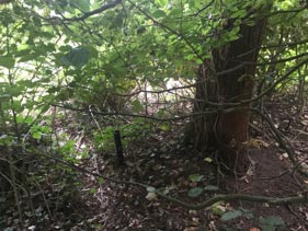
The detached properties here have drives at their gable ends. Between the drives is a 1 metre wide area of garden separating them. The hedgerow consists of well established Escallonia. The centre of the garden area has a number of metal spikes at various positions along its length. The large trunks of the Escallonia appear to follow the centre point. It is logical to assume the border follows the centre point of the garden area.
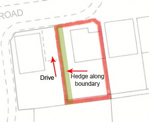
The detached properties here have drives at their gable ends. Between the drives is a 1 metre wide area of garden separating them. The hedgerow consists of well established Escallonia. The centre of the garden area has a number of metal spikes at various positions along its length. The large trunks of the Escallonia appear to follow the centre point. It is logical to assume the border follows the centre point of the garden area.
A look at the Title Plan shows the boundary for the property on the right, as that shown with red edging, which includes the garden area. A rough measurement of each plot, with the property on the right including the garden area, is the same size. In this instance the Title Plan shows the true boundary position accurately enough to determine ownership of the boundary.
Paper Documents
Paper documents are not always available today, having been mostly superseded by digital documents. However there are some still available where extrinsic evidence is needed, e.g. the replies to enquiries form completed for a solicitor by the vendor, architects blueprints, building regulation and planning application documents.
Digital Documents
These are the Land Registry documents that are supplied with a Boundary Search, and include the registered documents belonging to each of the properties in dispute, i.e. each side of the boundary. They comprise the Title Registers, Title Plans and Associated Documents, Deeds Plans, a Lease and Lease Plan if one of the properties is leasehold, an illustrated guidebook and details of common law boundary presumptions that apply if there is no evidence to the contrary.
Definition of a Boundary
There is both a legal definition of a boundary and a physical definition, and the two are not necessarily the same.
The legal definition uses a notional dividing line between two adjoining properties. This line is reasonably accurate but when it comes to measuring down to centimetre size the precision is lost. Determining the precise measurements and precise boundary locations, however, are often what is required in a boundary dispute as most disputes pertain to small narrow stretches of land, usually a garden.
The physical definition requires an "on the ground" inspection, using physical geographical features where available, such as hedgerows, ditches, streams, walls, etc. When a boundary is defined by using physical features, best practice dictates that the boundary should pass either along the centre of the physical boundary, or along one side or the other of it. This is because some boundaries change in size and may even move. For example a hedgerow will grow outwards and a river may change its course.
Land Registration Act 2002 section 60 (1)
This Act of Parliament brought up to date the Land Registry's convention with regard to property boundaries. The role of the Land Registry has never been the defining of property boundaries, but to provide an efficient and reliable means of record keeping with regard to the ownership of property and the terms upon which it is owned.
Previous to the 2002 Act the Land Registry were following the General Boundary Rule, as defined by the Land Registration Rules of 1925, Rule 278. Section 60 of the 2002 Act embodies this in statute. The boundary of a registered property shown on the title plan and mentioned in the title register is shown and described in a general way, unless the exact line of a boundary has been determined by the Land Registry following an application to them by one of the adjoining owners. The Land Registry only proceed with such an application if you have already agreed the boundaries with your neighbour, and do not involve themselves in disputed boundary matters.
Almost all boundaries are shown as general boundaries, i.e. boundaries that are not shown with precision and do not contain measurements, angles or dimensions. The Land Registry try to be as accurate as possible, but obviously this falls down with small, narrow parcels of land, which most disputes involve.
Boundary Search
Of all the methods available to resolve boundary dispute issues the speediest and most economical method is to look at the digital documents held by the Land Registry, as supplied in our Boundary Search. These documents must be sifted through carefully, looking for specific particulars relating to the boundaries, and also looking for indirect information that will provide accurate boundary cues or descriptions.
Some of the documents included with the Boundary Search may contain T marks, measurements, angles, etc. These are usually the Deed Plans and Lease Plans. They are sometimes professionally drawn and sometimes hand drawn. However, the evidence they provide is substantial.
The Boundary Search can be obtained from us for any number of property boundaries that are disputed. It is not necessary that the properties have a postal address. Every method of settling a boundary dispute will commence with a look at the available paperwork, so obtaining the search will never be a waste of time or money.
Other Articles in this Series
Title Register
The Land Registry Title Register holds data relating to the property ownership, purchase price, mortgage, tenure, covenants, rights of way, leases and class of title.
£19.95Title Plan
The Title Plan shows an outline of the property and its immediate neighbourhood, and uses colours to identify rights of way, general boundaries and land affected by covenants.
£19.95Associated Documents
Deeds creating Restrictions, Covenants, Easements, etc. are often kept digitally by the Land Registry and made available for sale due to their invaluable detail and content to assist in further understanding the Restrictions, etc.
£29.95


Links from this page
Help and Support
Information Hub Search
Was your question answered?
If you have any further questions regarding any of our products or services please feel free to contact us.
Land Registry Services are leading specialists in property data, conveyancing documents and environmental reports. Land Registry Services is neither owned or operated by the UK Government.