Property Boundaries Title Registers and Title Plans
Contents
Overview
The Title Register and Title Plan are designed to be read together as the one refers to the other. They each describe the property but in different ways, the Register using written words and the Plan using words, symbols and a drawing.
Working with one and not the other will often give an incomplete perspective of the property owned and sometimes will simply not make any sense. Further, when there is a Boundary Dispute it is often the case that the Title Register and Title Plan will provide complementing evidence of boundary responsibility. This article seeks to demonstrate, from an actual example, the importance of using the Title Registers and Title Plans of each property.
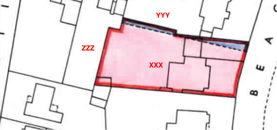
Title Register and Title Plan for the XXX Property
The examples below relate to two properties that adjoin each other, and in respect of which there are boundary issues. for clarity I will refer to the prime property as the XXX property, the property to the north as the yyy property and the property to the west as the ZZZ property.
There is one part of this Title Plan that immediately raises a question. The boundary to the north is oddly shaded blue whilst the remainder is shaded pink. Another important matter involving the eastern boundary is silent on the Title Plan and without the Title Register that matter would not be known.
Clause 1 under Section C of the Register (the Charges Register) states as follows:
“A Conveyance of the land tinted blue on the filed plan (i.e. the Title Plan) and other land dated 12 June 1870 made between (1) xxx and (2) zzz contains covenants details of which are set out in the schedule of restrictive covenants hereto.”
So with regard to the north boundary and the blue tinting, that part of the property is subject to restrictive covenants that do not affect the remainder of the property. Details of those covenants are set out in a schedule of restrictive covenants in the Title Register.
Clause 2 goes on to explain that in a similar way the part of the property tinted pink is also subject to restrictive covenants (of a different nature).
The wording of Clause 2 acts also as confirmation that the blue tinted part of the property, notwithstanding the dotted line, is within the same ownership as that tinted pink, as the XXX Property, is bound by the said covenants, which have been made in favour of the YYY Property.
The schedule of restrictive covenants is iterated at the end of the Title Register in considerable detail. Clauses 1 (1) and (2) of the Schedule refer to the existence of T marks and a covenant to maintain the eastern boundary of the XXX property and sub-clause 2 (1) and 2) provide measurements. Notes to Clause 2 (7) relate to the eastern boundary of the XXX property and refer to T marks also, and provide details of the dimensions of the eastern boundary.
The T marks do not appear in the Title Plan, but Clause 2 (1) of the schedule refers to a plan that does contain them. This is a sale plan that would have been received by the purchaser from the selling agent and is not part of the registered documents. The relevant clause is worded:
“1 Each purchaser is forthwith to make and afterwards to maintain boundary fences on the sides of his lot or group of lots marked T within the boundary on the SALE PLAN.”
This is how the notes to Clause 1 (7) are worded:
“NOTE 1: The eastern boundary of the land tinted pink on the filed plan is marked T as referred to in clause (1) above.
NOTE 2: The building line referred to in clause (2) above is set back 30 feet from the frontage.”
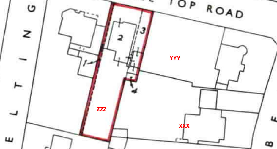
Title Register and Title Plan for the ZZZ Property
In the Title Register for the property to the west of the XXX property, two Abstracts of Title have been copied by the Land Registry. These will contain extracts from a number of purchase deeds and the like, stretching back at least 15 years and which will show a good root of title. These documents would usually contain more detail and may provide further evidence relating to boundary ownership between the properties. They would be obtained as part of our Boundary Search.
Clause 3 of the C Section of the Register provides that the purchaser shall erect a fence along the eastern and northern sides of their land, the ZZZ property. Accordingly, this would mean that the owner of the XXX property shown above in the XXX Plan would not be responsible for the western border of his property. A visual representation of this is gleaned from the Title Plan extract below, for the ZZZ property. Plots 3 and 4 of the property edged in red make up the west boundary of the XXX property (east boundary of the ZZZ property).
Conclusion
Title Plan and Title Register for the XXX Property:
- The east boundary is the responsibility of the XXX Owner - T marks on the Sale Plan (not shown in this example).
- The east face of the house, built to the building line, is 30 feet from the frontage.
- The north boundary is the responsibility of the XXX Owner demonstrated by the existence of a covenant to erect a fence.
Title Plan and Title Register for the ZZZ Property:
- The west boundary of the property to the XXX Owner, is the responsibility of the ZZZ Owner.
Boundary Search 2 Properties
Obtain all the available property documents held to help resolve common boundary problems. For 2 Adjoining Properties.
£99.95Boundary Search 3 Properties
Obtain all the available property documents held to help resolve common boundary problems. For 3 Adjoining Properties.
£146.95Boundary Search 4 Properties
Obtain all the available property documents held to help resolve common boundary problems. For 4 Adjoining Properties.
£193.95


Links from this page
Download Documents
Help and Support
Information Hub Search
Was your question answered?
If you have any further questions regarding any of our products or services please feel free to contact us.
Land Registry Services are leading specialists in property data, conveyancing documents and environmental reports. Land Registry Services is neither owned or operated by the UK Government.