Neighbourhood Profile
Contents
Article Summary
All people are interested in knowing about the neighbourhood in which they live, or in which they are thinking of moving to. This article describes our neighbourhood Search, which is prepared by recognised environmental authorities, and which provides all the information most people are looking for. This includes crime, education, shopping, planning, mobile masts, housing types, council tax bands, etc.
Neighbourhood Report
When we are considering moving house we usually like to know about the area we are moving to, and accordingly we will drive around and walk around the locality and get to know it better. However, there are many things that cannot be seen, or facilities that are not easily identified, and it is for this reason that our Neighbourhood Report was created. This report provides details of all matters a person would usually want to know about their new neighbourhood.
Contents of the Neighbourhood Report
The report is about 40 pages long and is divided into the following sections:
- Aerial Photograph
- Planning
- Land Use
- Public Rights of Way
- Housing
- Population
- Crime
- Education
- Crime
- Amenities
- Miscellani
Aerial Photograph
The aerial photograph is centred on the property and is provided at an image resolution of 50cm. It shows the neighbourhood for 250m all around.
Planning
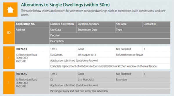
The Planning section is detailed and tabulated, and provides assistance in understanding the contents.
There is a detailed map showing the location of nearby residential planning applications, followed by a tabulated list specifying the type and state of each application.
Sample section of a tabulated list:
Another detailed map follows, illustrating non-residential planning applications, followed by a detailed analysis.
Land Use
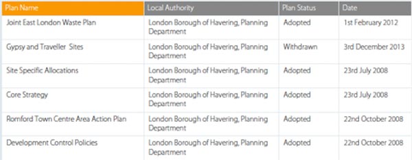
Every local authority produces a series of development plans that outline their approach to land use and development in their area. The plans they prepare provide an indication of the types of development they may encourage or restrict in the future.
This section of the Neighbourhood Search considers the council's development plans and maps, then summarises those that apply to the property area.
Sample section of a Development Plan summary
To support the tabulated summaries there is a detailed plan for the property area.
Public Rights of Way
A public right of way is the legal right to use a specified route through grounds or across property that belongs to someone else. The search produces an OS map extract showing the rights of way within 250m of the property. The rights of way shown include footpaths, bridleways, byways open to all traffic, roads used as a public path, national trails, recreational paths, permitted bridleways, permitted footpaths and cycle routes.
Housing
The section on housing offers information as to the ownership, type and average prices of property in the neighbourhood, together with council tax banding information.
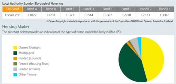
Much of this information is provided graphically, with the use of tables and pie charts as in the sample above.
Population
Charts and graphs show the breakdown of the local population in three groups: qualifications, age and occupation.
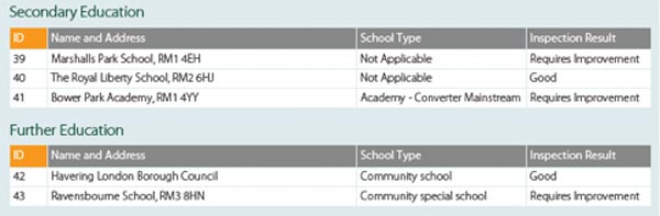
Education
The detailed map provided by the neighbourhood report in this section shows all schools within 2km of the property. They are then detailed in grouped lists divided into the categories of primary education, secondary education, further education and other schools and education centres, as in the sample below:
Crime, Amenities and Miscellani
Statistics and comparisons relating to crime and types of crime are provided, together with details of local amenities, shopping, etc, and other pertinent matters relating to the neighbourhood.
Rights of Way Search
The Rights of Way Search provides Land Registry documents detailing all private rights of way that affect the property having the benefit of and the property having the burden of the right of way, and also provides Environmental documents that detail public rights of way.
£139.95Boundary Search
The Boundary Dispute Search provides copies of all available Land Registry documents for the properties on each side of the boundary, together with details of common law presumptions that will apply where there is no evidence to the contrary.
£99.95Parking Space Disputes
Parking Dispute searches provide details of all registered documents that contain references to parking spaces, drives, etc, whether on street or off street
£64.95

Links from this page
Help and Support
Information Hub Search
Was your question answered?
If you have any further questions regarding any of our products or services please feel free to contact us.
Land Registry Services are leading specialists in property data, conveyancing documents and environmental reports. Land Registry Services is neither owned or operated by the UK Government.