Map Search Large or Tiny Parcel of Land
Contents
Overview
A well defined area of land on a map is easily identified by dropping a pin, as with our standard map search. However, some searches require large areas of land, sometimes miles long, sometimes narrow areas, both of which may encompass many separate properties. Other searches may be required to identify small areas of land adjoining a larger property. Dropping a pin would most likely swing into the larger property’s parcel. This Map Search is quite distinct from the standard version. Rather than dropping a pin, you trace around the outline of a map, roughly at first, and then fine tune it so that it illustrates precisely where you want us to search. An exact copy of this is received by us together with your search instructions.
How to Use the Map Search
1. Enter an Address or Postcode
The first and simplest option to navigate to your desired location on the map is to use our geolocation feature. Enter a postcode or part of an address, press return or click the 'Go' button and the map will automatically move to that location and place the marker in the centre of that area. You can then move the map by dragging it with your mouse to the exact location you need. Note: Even though you do not type in a full postal address, the address field will auto populate to the nearest property with a full postal address. Do not be concerned with this, as we will search the property you have traced around. The feature is there to assist our staff in rapidly locating the vicinity to be searched.
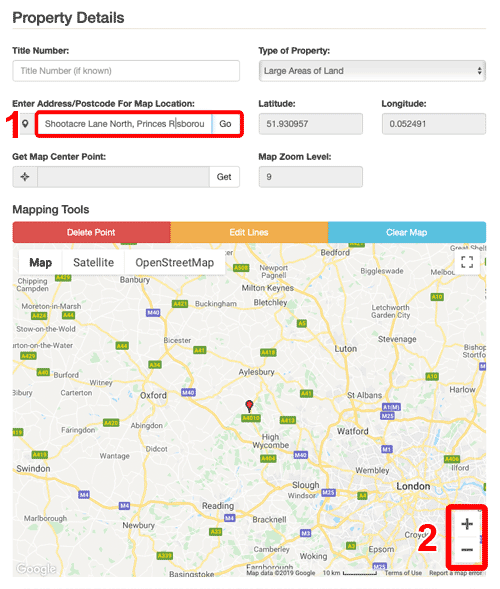
2. Zooming into the Map
The mapping tools include [+] and [-] icons to zoom into and out of the map. You can also use your mouse scroll wheel along with the 'cmd' or 'Command' key to zoom in and out of the map.
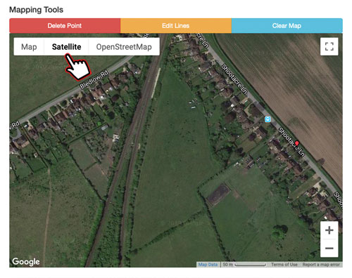
3. Use Satellite View
To further check or refine the exact location of the area that you would like us to search, we recommend switching to Satellite view. Satellite view shows an image of the area you're looking at including roads, buildings and hedges.
4. Marking the Map
Use your mouse to mark points on the map. Clicking on a location on the map will start the marking process, subsequent clicks will draw a straight line between the points. Please try and be as precise as possible, we will only be able to search property within marked areas. If you make a mistake you can click the 'Delete Point' button which will erase the last point marked on the map. You can delete further points by clicking the button again. If you need to edit a point mid way along your mapped outline, clicking the 'Edit Lines' button will make each marked point editable. You can then drag the point to its correct location. Please remember to click 'Stop Edit' after you're done. You can zoom into the map to fine tune the position or even make the map full screen by clicking the icon in the top right corner of the map. To exit full screen mode, click the icon again. To reset the marked outline click the 'Clear Map' button. Please note that clearing the map cannot be undone.
The images below show examples of the map editing tools in use.


Single Plots of Land
This search enables you to obtain the ownership details of a single plot of land, either by dropping a pin onto a built-in map on our application form, or by tracing its outline onto the map.
£29.95Large Areas of Land
This search enables you to obtain the ownership details of a large area of land, whatever its nature, size or shape. Our fee includes the Title Registers for the first 5 Titles. You will be advised of the cost of proceeding with any remaining Titles, which will be charged at £4.95 each.
£89.95Woodland Searches
This search enables you to obtain the ownership details of a parcel of woodland, forest or moorland. If more than one Title is discovered you will be advised of the cost of obtaining further Titles.
£29.95


Links from this page
Help and Support
Information Hub Search
Was your question answered?
If you have any further questions regarding any of our products or services please feel free to contact us.
Land Registry Services are leading specialists in property data, conveyancing documents and environmental reports. Land Registry Services is neither owned or operated by the UK Government.