Land Registry Plans
Contents
Article Summary
The Land Registry Title Plan has a specific purpose. This article will explain its purpose and will distinguish it from other plans available from the Land Registry such as Deed Plans, Lease Plans and drawings to support planning and building regulation consents (blue prints).
Title Plan
Rules made under the land Registration Rules 2003 (Rule 5) state that the Land Registry shall maintain a Plan that is to be based on the Ordnance Survey and that it should be referred to in the property description provided in the Title Register.
The description of the property address in the Register is improved considerably by the Title Plan. It is described in the Register as being land outlined in red edging, and so what words do not appropriately describe, particularly where there is no property address, the plan will better describe. It is best practice to obtain a Title Plan at the same time as obtaining a Title Register so as to have a complete description of the property owned.
Title Plans are always drawn to scale. In urban areas the scale is 1:1250 and in rural areas it is 1:2500. The smaller scales of 1:5000 and 1:10000 are used in more remote areas. Title Plans are always printed with north facing upwards, confirmed by a compass drawing on the plan.
Coloured Tints and Hatching
Parcels of land within an ownership that are affected by rights of way or specific covenants are usually tinted are hatched in colours, the meaning of which is shown in the Title Register, which will describe colours, e.g. in the following way:
Sample extract from Title Register referring to coloured tinting in the Title Plan
Property Register
This register describes the land and estate comprised in the title
City of Westminster
1 (05.07.2014) The Freehold land shown edged with red on the plan of the above Title filed at the Registry and being Hale House, Heavens Gate, Lond SW6 1SE.
2 The Land has the benefit of the rights of way over the land tinted brown and rights of user over the gardens tinted blue on the title plan on payment of a proportionate part of the charges and expenses of maintenance.
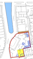
Colouring Conventions used in Title Plans
Coloured Tints and Coloured Hatching may be used in Title Plans, as follows:
- Brown - Benefit of Easements such as rights of way or rights of drainage
- Pink - Covenants
- Light Blue - Different Covenants
- Light Blue - Burden of Easements
- Yellow - Right of Pre-emption
- Green - Green edging is used to denote land removed from the Title
T marks and H Marks
Title Registers to not often contains T and H marks. When they do, the bar of the T is placed upon the boundary side that has ownership or responsibility for the boundary. H marks denote an equal responsibility. These markings are more often contained in Deed Plans.
Accuracy
Land Registry Title Plans are not designed to be precise. They do not contain measurements, angles, dimensions or any other indication of accuracy, unless the boundary is a Determined Boundary as defined by the Land Registration Act 2002. Otherwise, boundaries are shown in a general way only. Although reasonably accurate their precision fails at the "inches" level.
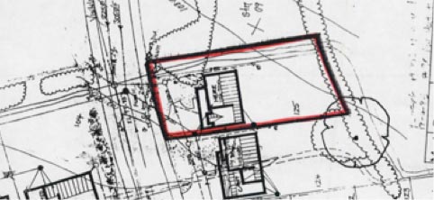
Deed Plans
Many of the Associated Documents, e.g. conveyances, transfers and agreements, contain plans that have either been professionally created, or hand-drawn. Unlike Title Plans they more often than not contain T and H marks. They frequently contain measurements, also.
Sample Deed Plan containing measurements and boundary notes
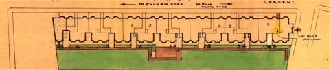
Lease Plans
Almost every Lease has a Lease Plan attached to it. The detail in a Lease Plan usually surpasses in usefulness the detail in a Title Plan and is accurate in showing the position of car parking spaces, bin stores, shared gardens, common parts of the property, etc.
Lease Plan Extract
Blueprints (House Plans)
Blueprints are the drawings professionally created by architects, structural surveyors and building engineers, usually with the purpose of supporting an application for planning consent or building regulation approval. They are not kept by the Land Registry but by the local authority.
Title Register
The Land Registry Title Register holds data relating to the property ownership, purchase price, mortgage, tenure, covenants, rights of way, leases and class of title.
£19.95Title Plan
The Title Plan shows an outline of the property and its immediate neighbourhood, and uses colours to identify rights of way, general boundaries and land affected by covenants.
£19.95Associated Documents
Deeds creating Restrictions, Covenants, Easements, etc. are often kept digitally by the Land Registry and made available for sale due to their invaluable detail and content to assist in further understanding the Restrictions, etc.
£29.95


Links from this page
Help and Support
Information Hub Search
Was your question answered?
If you have any further questions regarding any of our products or services please feel free to contact us.
Land Registry Services are leading specialists in property data, conveyancing documents and environmental reports. Land Registry Services is neither owned or operated by the UK Government.