Fishing Rights on Rivers
Contents
- Riparian Ownerships
- Rights and Obligations of Riverbank Owners
- Registrable Classes of Riverbank Ownerships
- Fishing Rights Search
- Fishing Rights Title Documents
- Index Map Search (SIMR)
- Index Map Plan
- Fishing Rights Title Register and Title Plan
- Fishing Rights Deed
- Riparian Owner's Title Register
- Riparian Owner's Title Plan
- Popular Fishing Rivers
Article Summary
The Land Registration Act 2002 introduced, for the first time, the right to register Fishing Rights at the Land Registry with their own unique Title, even though the riverbank itself is owned by someone else. This article will examine the right to register Fishing Rights, Riverbank Ownerships, and how to obtain copies of the ownership documents relating to riverbanks and fishing rights.
Riparian Ownerships
Riparian ownership is another way of saying Riverbank Ownership, and the term generally extends, not only to riverbanks, but to ordinary watercourses such as streams, river islets, the banks of weirs and dams, pipes, dykes, drains, sluices, rills, culverts and private sewers. Some riverbanks are owned by fishing clubs but many are owned by private landowners.
The Common Law (based on decisions of the High Court) assumes that a riverbank owner owns all of the land up to the midway point of the watercourse unless the ownership documents contain evidence to the contrary. Evidence to the contrary may become patent where a garden backs onto a watercourse, but a physical feature such as a wall, fence or hedge lies between the garden and watercourse. Looking at the Title Register, Title Plan and Associated Documents would indicate whether ownership extended beyond the intervening physical feature, in which case ownership would then be assumed to extend to the midpoint of the watercourse.

Where a watercourse has been created by man, e.g. where it is a culvert, the watercourse may be owned by a third party. Again, the Title Documents should show this.
Riparian owners will have various rights and obligations as a result of their ownerships, all of which can be determined by examining the ownership documents.
There are 2 types of watercourses:
- Ordinary Watercourses
- Main Rivers
Main Rivers are regulated and maintained by the Environment Agency and are not discussed in this article. All further references and remarks relate to ordinary watercourses.
Rights and Obligations of Riverbank Owners
Riparian owners will have various rights and obligations as a result of their ownerships, all of which can be determined by examining the ownership documents. Rights and obligations may include the following, depending on one's class of ownership, and would normally be spelt out in the Deed creating the ownership, i.e. the Associated Documents for that Title. Where the right is a Fishing Right the principal Deed will be the Fishing Rights Deed, which would not normally pass obligations to a Fishing Rights Owner. The Fishing Rights Deed is one of the documents that would be included in our Fishing Rights Search.
Rights
- Water should naturally flow along the watercourse without being impeded upstream, and without being polluted.
- There may be limited rights to abstract water.
- The right to protect your land from flooding and erosion.
- The right to fish, although you may need a licence to do this.
Obligations
- In the same way that you have a right for water to flow along your watercourse, you have an obligation to allow water to continue to flow beyond your watercourse, and without polluting it.
- You are obliged to allow floodwater onto your land.
- You must maintain the riverbank and riverbed, e.g. by removing obstructions.
- The control of alien invasive vegetation.
- To protect your riverbank from water seepage that may cause damage elsewhere.
Failure to abide by these obligations may result in the service of a notice upon you by your local authority, under the Land Drainage Act 1991, requiring you to complete specified work to your watercourse.
Registrable Classes of Riverbank Ownerships
A typical stretch of riverbank owned privately on a popular fishing river, may include the following rights, all of which can be registered at the Land Registry, all of which will have their own unique Title Numbers, Title Registers, Title Plans and Associated Documents. All of these documents can be obtained by applying for a Fishing Rights Search.
- Fee Simple Absolute in Possession - This is the Freehold ownership of the Riverbank.
- Term of Years Absolute - This is a Leasehold ownership of part of the freehold Riverbank.
- Profits a Prendre in Gross - These are the various Fishing Right titles granted for different stretches of the Freehold or Leasehold Riverbank.
- Ownerships of Easement Land lying between the riverbank and a public right of way, such as a road.
Fishing Rights Search
A Fishing Rights Search includes the following documents:
- Index Map Plan - this displays the various registered titles along a specified stretch of riverbank.
- Freehold or Leasehold Title Register and Title Plan - the owner's own registered title.
- Fishing Rights Title Register and Title Plan - this pertains to the Fishing Rights Title that you are interested in.
- Easement Land Title Register and Title Plan - this is an optional extra, where you may wish to see the documents for the property over which you will have to pass to reach the riverbank.
- Fishing Rights Deed - this is the Deed that created your Fishing Rights.
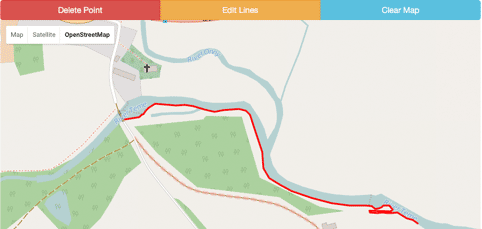
When making your search and completing the application form you will be required to identify the stretch of riverbank that you are interested in. This is easily done by using the built in Advanced Map, as above. You will zoom into the general area on the map, and once you are happy you can see it, you can then trace the outline of the property to be searched (shown in red). We receive an exact copy of this with your application form, from which we can readily identify the property.
Fishing Rights Title Documents
- Index Map Search (SIMR) and Index Map Plan
- Fishing Rights Title Register
- Fishing Rights Title Plan
- Fishing Rights Deed
- Title Register of the Riparian Owner (Freehold or Leasehold)
- Title Plan of the Riparian Owner (Freehold or Leasehold)
Index Map Search (SIMR)
This is a document we obtain that will show up to 5 registered Titles affecting the land in question.
Extract from SIMR Search
The Index Map has been searched in respect of the Property with the following result
| Plan reference | Title No | Registered Estate |
| Tinted Pink | CU00119993 | Freehold |
| Tinted Blue | CU00119901 | Freehold |
| Tinted Yellow | CU02121299 | Freehold |
| Striped Blue | CU93974756 | Leasehold profits a prendre in gross |
Part of the Property is unregistered.
The attached Land Registry index map plan has been prepared for the sole purpose of showing the area in respect of which an official search has been made. The information has been taken from the index map and is illustrative only.
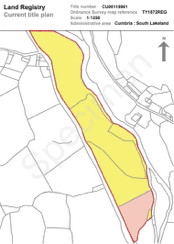
Index Map Plan
The Index Map Plan illustrates, using coloured tints, the parcels of land referred to in the Index Map Search Result (SIMR). From this document and the SIMR we are able to identify the respective property documents to obtain for you.
Fishing Rights Title Register and Title Plan
Extract from the A Section of a Fishing Rights Title Register
Property Register
1 (11.01.2007) The Leasehold profit a prendre in gross being the right to fish with rod and line (but not more than three rods at any one time) and to take and carry away fish from the western moiety of the River Stint, Leverton, Ulverston between the points lettered A and B in blue on the plan of the above title filed at the Registry.
2 (11.01.2007) An Assignment dated 02.01.2007 made between (1) George Sweeney and (2) Stanley Dodd is expressed to grant rights which benefit the registered estate in this title.
Note: copy filed
3 (11.01.2007) Short particulars of the lease under which the profit a prendre in gross is held:
| Date | : | 2 January 2007 |
| Term | : | 999 years from 2 January 2007 |
| Parties | : | (1) James Albright |
| (2) Madeleine Burns |
Proprietorship Register
Title Good Leasehold
1 (11.01.2007) Proprietor: Jonathan Stephen Smart of 93 Miles Lane, Millom, Cumbria LA17 9RS.
2 (11.01.2007) The price stated to be paid on 2 January 2007 was £12,000.
As will be seen from the above The Fishing Rights Register provides full details of the title, much as the freehold title would, but it is confined to the Right to Fish. Fishing Rights can only be registered where the Rights have been granted by Deed for a period of at least 7 years. The owner of the leasehold estate in the property out of which the Rights have been granted has assigned his Rights to the Fishing of the Riverbank to the proprietor of this Title.
The Register notes the Lease from which the Rights have been assigned and gives brief details of it. The note that a copy has been filed means that a copy of the Assignment is available for purchase, and this would normally be provided with the Fishing Rights search.
The Fishing Rights, for this property, are limited to fishing with a rod and line, and to use no more than 3 rods at a time. Only the western bank of the River Stint is to be fished, represented by a line on the Title Plan between letters A to B, which follows the river bank between those 2 points.

Other common restrictions on fishing that are sometimes included:
- Game fish only
- Particular species of fish
- Bag limit (this may differ for different species of fish)
- Catch and release
- Single hooks only
- Landing fish while still in the water
- Fish size limits
- Type of landing net
Fishing Rights Deed
All profits a prendre in gross, to be registered at HM Land Registry, must be created by a Deed of at least 7 year's duration. A Deed is a legal document that is created in writing, signed by the parties as a Deed, and witnessed.
The following is an extract of the salient features of the Fishing Rights Deed giving rise to the registration referred to above. The details are contained in the Schedule to the Deed.
THE SCHEDULE
ALL THAT the right and privilege for the Purchaser and those authorised by him to fish with rod and line (but with not more than three rods at any one time) and to take and carry away for his or their own benefit fish from that part of the west bank of the River Stint at Leverton Bridge in the Parish of Ulverston as lies to the south of the Leverton bridge aforesaid and extends to approximate 350 yards and as to one half of the width of such river as is more particularly shown on the plan annexed hereto and coloured yellow TOGETHER also with (for the purpose only of enjoying the rights hereby granted and only so far as applicable thereto) the right to perambulate the River Bank and to trim such bushes trees and shrubs along the said Bank as may be an obstruction to fishing and cut such reeds and other water plants as may be detrimental ….
Riparian Owner's Title Register
The Riparian Owner's Title Register will describe the property owned, and refer to it as being the land edged with red on the Title Plan.
Sample extracts of the Riparian Owner's Title Register
Extract from Section A (Property Register)
CUMBRIA : SOUTH LAKELAND
1 (03.05.1996) The Freehold land shown edged with red on the plan of the above Title filed at the Registry and being land adjoining Elslack Water, Leverton, Ulverston.
NOTE: The strip of land measuring inwards two metres from the Riverbank is excluded from the title.
Extract from Section C (Charges Register)
1 (03.05.1996) A Conveyance of the land tinted yellow on the filed plan and other land dated 19 August 1964 made between (1) Julia Tompkins (the Vendor) and (2) William Caskin (the purchaser) contains the following covenants:
The Purchaser hereby covenants with the Vendor as follows:
The Purchaser shall not do or permit any act or thing to be done or omitted whereby the water in the said River Stint may be polluted so as to cause any injury to the fish in the said river.
2 (03.05.1996) The land is subject to the following rights reserved by a Conveyance of the land in this title dated 12 April 1996 made between (1) George Hill (the Vendor) and (2) Eric Sommes (the Purchaser):
"EXCEPT AND RESERVING unto the Vendor and and his successors in title …… all necessary rights of access ……. to ……. the river bank to enable the Vendor to fish from the Riverbank and with any necessary machinery for the purpose of maintaining the same the Vendor doing as little damage as possible in the exercise of such rights and making good any damage unavoidably caused."
Riparian Owner's Title Plan
The Title Plan of the riparian owner clearly shows the extent of the property owned by him, which includes the riverbank over which he has sold the Fishing Rights. The Register shows that the riparian owner is himself obligated to keep his stretch of the river free from pollution and obstruction.
Popular Fishing Rivers in England and Wales
- River East Lyn, Exmoor
- River Test, Hampshire
- River Tweed, Borders
- River Frome, Dorset
- River Piddle, Dorset
- River Itchen, Winchester
- River Kennett, Marlborough
- River Coln, Gloucestershire
- River Ribble, Preston
- River Meon, Hampshire
- River Ure, Wensleydale
- River Wye, Derbyshire
- River Dove, Derbyshire
- River Eden, Cumbria
- River Esk, North Yorkshire
- River Tamar, Devon
- River Avon, Hampshire
Fishing Rights Search
The Fishing Rights Title will also contain a copy of the Deed creating the fishing rights and this will usually state the amount and type of fish that can be caught.
£69.95Flood Risk Report
The most comprehensive and detailed Flood Risk report available, providing information supported by detailed maps for Sea and River Flooding, Rainwater Flooding and Groundwater Flooding.
£54.95Property Map Search
We can identify land and buildings with pin-point accuracy even where there is no address. Our application form contains a built in map that allows you to mark or outline the land.
£29.95


Links from this page
Help and Support
Information Hub Search
Was your question answered?
If you have any further questions regarding any of our products or services please feel free to contact us.
Land Registry Services are leading specialists in property data, conveyancing documents and environmental reports. Land Registry Services is neither owned or operated by the UK Government.