Definitive Rights of Way Map
Contents
Article Summary
All county councils or unitary authorities in England and Wales have a legal duty to provide and review public rights of way maps, which are known as Definitive Maps and Definitive Map Statements, which support them. These maps show footpaths, bridle ways, byways open to all traffic, restricted byways, roads used as public paths and unmarked footpaths (e.g. a stile at each end of a field but no path between). This article describes definitive maps and statements and provides links to each local authority's maps.
Definitive Map
A definitive map is an official map provided by the Council or Unitary Authority for the area in which the rights of way exist, and this applies throughout England and Wales save only for the inner boroughs of London. The maps distinguish between the different types of public rights of way, such as:
- Footpaths
- Bridle ways
- Byways open to all traffic
- Green Lanes
- Restricted Byways
- Permissive Paths
- Rights of Way with No Visible Path
The definitive map will provide the name of each right of way, sometimes by reference to the parish in which it is situated, and together with its identification number, e.g. "Matlock Public Footpath 70".
Definitive Map Statements
A definitive map statement is also provided to support the maps. This will provide a list of all public rights of way for the county, with a description of each, details of the surface, the width and any other relevant information.
Public Right of Inspection
As definitive maps are public maps they must be kept available for all members of the public to view. This is generally done by providing the map on the county council's website, and allowing free access to it.
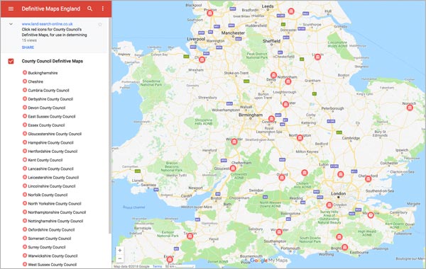
Google Map Displaying Online Definitive Map Access
Definitive Map Links
County Councils
- Buckinghamshire County Council
- Cheshire County Council
- Cumbria County Council
- Derbyshire County Council (link to email to arrange appointment to view)
- Devon County Council
- East Sussex County Council
- Essex County Council
- Gloucestershire County Council
- Hampshire County Council
- Hertfordshire County Council
- Kent County Council
- Lancashire County Council
- Leicestershire County Council (link to email to arrange appointment to view)
- Lincolnshire County Council (viewing information)
- Norfolk County Council
- North Yorkshire County Council
- Northamptonshire County Council (viewing information)
- Nottinghamshire County Council (viewing information)
- Oxfordshire County Council
- Somerset County Council
- Suffolk County Council (in progress)
- Surrey County Council
- Warwickshire County Council
- West Sussex County Council
- Worcestershire County Council
Rights of Way Search
If you are having problems with public or private Rights of Way you will need a Rights of Way Search.
Rights of Way Search
The Rights of Way Search provides Land Registry documents detailing all private rights of way that affect the property having the benefit of and the property having the burden of the right of way, and also provides Environmental documents that detail public rights of way.
£139.95Boundary Search
The Boundary Dispute Search provides copies of all available Land Registry documents for the properties on each side of the boundary, together with details of common law presumptions that will apply where there is no evidence to the contrary.
£99.95Parking Space Disputes
Parking Dispute searches provide details of all registered documents that contain references to parking spaces, drives, etc, whether on street or off street
£64.95


