Solving Boundary Problems with Official Documents
Contents
- Article Summary
- Types of Documents containing Boundary information
- Title Register
- Title Plan
- Associated Documents
- Deed Plans
- Leases
- Lease Plans
- Planning Documents
- Building Control Documents
- CRoW Maps
- Plans accompanying an estate agent's sales particulars
- Architects plans
- Conveyancer's property information form
- Boundary Search
Article Summary
There are a number of official documents available to help resolve a boundary problem. This article provides details of each of these documents, and how to obtain them. There are other, non-official documents that may also assist which are also described.
Types of Documents containing Boundary Information
The following documents will contain boundary information, although the information in the latter documents listed may be unreliable. Where that is so, the paragraphs below will indicate and explain why.
Official Documents
- 1. Title Register
- 2. Title Plan
- 3. Associated Documents
- 4. Deed Plans
- 5. Leases
- 6. Lease Plans
- 7. Planning Documents
- 8. Building Control documents
- 9. CRoW Maps
Non-Official Documents
- 10. Plans accompanying an estate agent's sales particulars
- 11. Architects plans
- 12. Conveyancer's property information form
Title Register
The Title Register provides a brief property description in its A section, usually comprising the address and a reference to the red edging in the Title Plan, as in the following extract:
1 (03.01.2003) The Freehold land shown edged with red on the plan of the above Title filed at the Registry and being 67 Stepney Street, Wavertree, Liverpool (L13 67N).
Where there is no postal address there will be a brief description of the land, as in the following extract:
1 (19.8.1969) The Freehold land shown edged with red on the plan of the above Title filed at the Registry and being land on the west side of Heddington Hall Farm, Plough Lane, Wilmslow (SK7 3EF).
Where Title Plans have been updated or amended, the A section of the Title Register will state so, as in the following extract:
1 (19.07.2000) A new filed plan showing an amended extent has been prepared.
Further, the A section may include party wall declarations, references to a Deed containing Boundary Wall Structure Notices, details of Easements or Covenants that contain either express or implied boundary information.
The following sample relates to some of the foregoing:
"The Conveyance dated 22 November 2001 referred to above contains provisions as to light and air and boundary structures and easements.
NOTE: Copy filed."
Large parcels of land may be divided and parts sold off. Where this occurs the Title Register for the property selling the parcel is noted accordingly, as is the Title Plan.
Land may also be added to the Title, and this is illustrated in the following extract:
8 (23.2.1978) The land edged and lettered C and D in red on the title plan was added to the title on 7 January 1978.
Title Plan
The Title Plan provides only a general illustration of the boundary positions. The property is described in the Title Register as being that within the red edging of the Title Plan. The red edging is inserted within the black edging on the standard OS maps. It is designed, because of section 60 of the Land Registration Act 2002 and the 2003 Land Registration Rules, to provide a general indication of the boundaries only, i.e. not a precise positioning, although the boundary positions are accurate in a general way.
Measurements, dimensions and angles are not included in the Title Plan. Where land has been removed from a Title it is shown on the Title Plan for the property selling it as being edged in green and the new Title Number for the land appears in green ink.
Title Plans are prepared to the following scales:
- Urban Areas - 1:1250
- Rural Areas - 1:2500
- Remote Rural Areas - 1:5000 or 1:10000
T and H marks do not usually appear in Title Plans.
Associated Documents
The Associated Documents are the Deeds prepared by conveyancers either in connection with the existing purchase or with older ones. The Land Registry use some of these to create the Title Register, or to update the Title Register. The most important information is copied into the Title Register, but not all of it.
The Deeds often contain information that is regarded as very important where boundary disputes are concerned. Hints and clues to boundary positions can often be ascertained from the wording of covenants, easements and other declarations contained in the Deeds.
Deed Plans
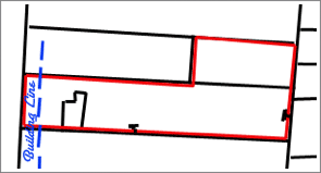
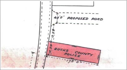
Deed Plans are sometimes professionally drawn and sometimes hand-drawn. They have strong persuasive authority where boundary positions are in question, and are prepared both when the property was first sold, and at other times when it has been necessary to pin-point part of the land or boundaries. They often contain precise measurements, dimensions and angles. Deed Plans are attached to Deeds. T marks and H marks are often included in Deed Plans, as in the example below.
Sample Deed Plan extract showing T marks:
Sample Deed Plan showing measurements:
Leases
Where one of the disputed properties is Leasehold the Lease should always be examined. Leases normally contain all the pertinent information concerning a property including the boundaries, car parks, gardens, etc. Although there may be no measurements relating to boundaries, the wording is usually precise enough to draw a conclusion. Leases for adjoining properties are likely to be very similar, and it is normally necessary to look at one of the leases only.
Lease Plans
Most Leases will have a plan attached to them. Lease Plans are usually very detailed and may contain measurements.
Planning Documents
Planning documents are not designed to deal with boundary positions, and so plans made by them may not contain additional information. Copies of planning documents may be obtained on payment of the copying fee from the local planning department. Any such plans are likely to be copies of the drawings provided by architects - the property blue prints.
Building Control Documents
Building Control documents may consist of drawings or notes made by a building inspector when checking the progress of work during a building project. If the property is to be developed to the boundaries there may be something of worth, although a building control inspector will not be thinking about boundaries or boundary disputes when making any drawings or notes.
CRoW Maps
CRoW Maps are those obtained from the Countryside and Rights of Way web site. They are free to download, but are designed to provide details of access land only (right to roam). The boundaries of access land are shown in a general way only.
Estate Agents Plans on their Sales Sheet
Any information procured by a selling agent is usually obtained from the vendor. It may be useful to obtain a copy of his sales sheet for properties sold in the past, but it is not likely he will have retained this. In any event the information therein may not be reliable, as it may be the vendor's personal interpretation of the boundary positions, unless he has evidence to support it, e.g. it was he who erected one of the fence or wall boundaries.
Architects Plans
These are the blueprints prepared by an architect in support of a planning or building regulation application, and which the developer will follow. There may be useful boundary information therein, and measurements affecting the boundaries. Quite often the Deed Plans are based on an architects drawing, and so any salient information he could provide may already be contained in the Deed Plans.
Conveyancer's Property Information Forms
These are completed by the Vendor when a property is being sold. They may be of value if they relate to boundary positions shortly after the property was erected. However, it is not likely the solicitors will have retained their files any longer than 6 years after the sale.
Boundary Search
A Boundary Search includes the following documents, for each of the adjoining properties:
- Title Register and Title Plan
- Associated Documents and Deed Plans
- Lease and Lease Plan (for one of the properties)
- Illustrated guidebook relating to Boundaries with samples
- Details of Common Law Boundary Presumptions (in the guide book)
The above are the most important documents, and are generally sufficient to resolve most property disputes. The small percentage that are not resolved from them may require a physical inspection of the property by a boundary expert such as Jon Maynard.
The cost of this search is £89.95.
Boundary Search 2 Properties
Obtain all the available property documents held to help resolve common boundary problems. For 2 Adjoining Properties.
£99.95Boundary Search 3 Properties
Obtain all the available property documents held to help resolve common boundary problems. For 3 Adjoining Properties.
£146.95Boundary Search 4 Properties
Obtain all the available property documents held to help resolve common boundary problems. For 4 Adjoining Properties.
£193.95


Links from this page
Download Documents
Help and Support
Information Hub Search
Was your question answered?
If you have any further questions regarding any of our products or services please feel free to contact us.
Land Registry Services are leading specialists in property data, conveyancing documents and environmental reports. Land Registry Services is neither owned or operated by the UK Government.